How live gas readings and plume modelling
kept this B.C. community safe
THE CHALLENGE
Flaring issues at an oil refinery, a neighborhood right next door
Parkland Refinery, in Burnaby, British Columbia, is directly adjacent to local residential neighborhoods, so community safety is always a top concern. While the Burnaby Fire Department doesn’t fight refinery fires—Parkland has its own internal team for that—their mission is to protect the city’s 249,000 residents, which includes keeping them informed when they might be at risk, and being proactive about evacuation and shelter-in-place orders when needed.

In early 2024, Parkland Refinery experienced flaring issues arising from equipment malfunction, which resulted in a plume of smoke that released air contaminants. According to Deputy Fire Chief Tyler O’Neill, the initial calls came in from citizens in the region who noticed the smoke and odor. The local neighborhood includes a commercial area, heritage houses, a community center, a senior’s center, and a library—and because the incident took place on a Sunday, the area was busy.
With the potential for hazardous chemicals spreading closer to the community, Burnaby Fire needed a fast and reliable way to monitor what was in the air, how the wind was moving, and what areas were most at risk so they could make data-informed decisions and mitigate harm.
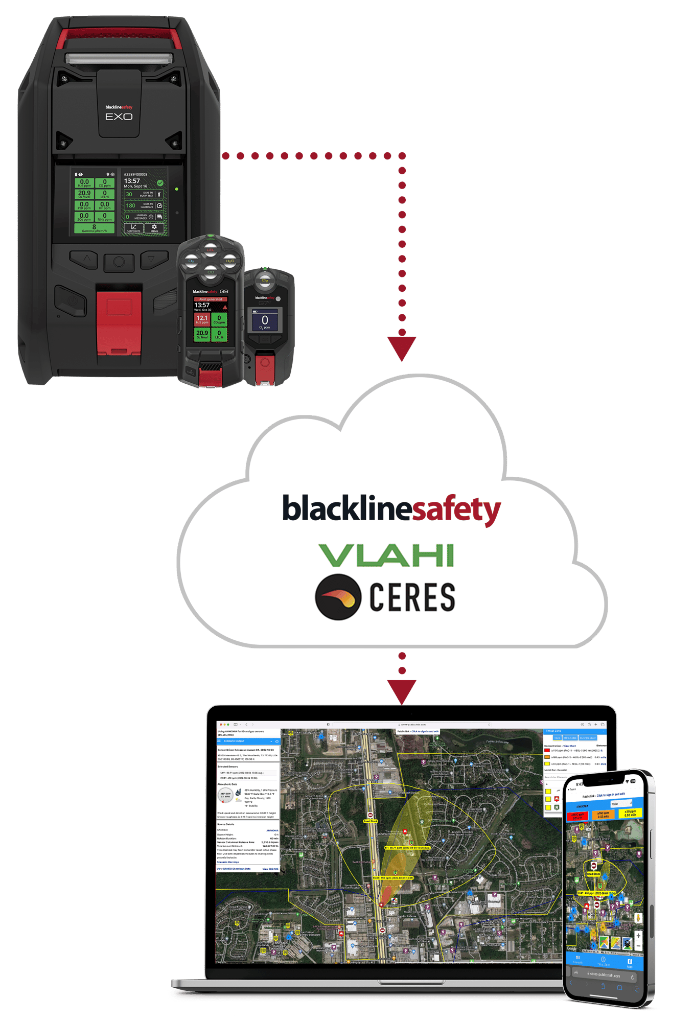
THE SOLUTION
EXO area monitors with Vlahi CERES plume modelling

Because there was no immediate danger to life or structure, the hazmat team arrived on scene and set up a perimeter around the Parkland area using eight EXOs—direct-to-cloud portable area monitors capable of detecting up to eight gases, plus gamma radiation. Each member of the hazmat team in the perimeter was equipped with a G7 wearable device with gas monitoring and lone worker protection to ensure their own safety as they worked in the potentially hazardous area.
Vlahi’s web-and smartphone-based CERES plume modelling tracks real-time gas plume dispersion using the data collected in the field from the EXO area monitors. Combined with live weather data taken from IBM weather or on-site meteorological stations, the technology develops real-time, location-stamped sensor gas readings and estimates a released gas’s downwind concentration to predict a plume’s size, speed, and direction of spread.
Burnaby Fire connected CERES to their own weather stations, which enabled them the most accurate mapping for plume. Even if it’s too late to evacuate an area, said Deputy Chief O’Neill, that level of accuracy gives teams the opportunity to provide real-time warning to immediate communities, and advanced notice to neighboring regions and services like airports.
After formulating a model of the plume’s movements, the team was able to prepare data-informed strategies for in case an evacuation or warning was necessary, while keeping an eye on the real-time movement of the plume.

“EXOs deploy as fast as you can take them out of the box and turn them on, and the plume modelling takes the guesswork out of how the plume is going to move in real time.”
Deputy Chief Tyler O’Neill | Burnaby Fire Department
THE RESULTS
Plume modelling and area monitoring drive informed decisions
The direction of the wind that carried the plume meant that surrounding citizens were safe to stay in their zones and no evacuation order was required. Burnaby Fire felt confident in that decision because they had the data to back it up thanks to EXO and CERES plume modelling.
Benefits realized include:
-
Real-time data—Instant information yields quicker, more informed decisions
-
Safer work conditions—Area monitors mean firefighters don’t need to stand at the fenceline of a possible disaster
-
Predictive modelling—Analyzing weather patterns helps teams get ahead of chemical releases accurately
Learn more about Blackline’s plume modeling technology.

AT A GLANCE

- Burnaby Fire used real-time plume modelling and portable area monitors to track a refinery smoke plume and assess community risk.
- Live gas readings and weather data enabled responders to predict plume direction and concentration in real time.
- Data-driven monitoring allowed officials to confidently avoid evacuation while keeping firefighters and residents safe.
STATS
8
EXO 8's deployed around the refinery perimeter
Up to 8
Gases + gamma radiation detectable per EXO device
1 Neighborhood
Protected without requiring evacuation